
“], “filter”: { “nextExceptions”: “img, blockquote, div”, “nextContainsExceptions”: “img, blockquote, a.btn, a.o-button”} }”>
Heading out the door? Read this article on the new Outside+ app available now on iOS devices for members!
>”,”name”:”in-content-cta”,”type”:”link”}}”>Download the app.
High tide is hours away, but I’m briskly marching along the Oregon Coast Trail to get up to Cape Meares and back before the water rises. If my friend, dog, and I linger too long, the surf will swamp our path in up to 7 feet of water, enough to block our way back to the car. And if we got stranded, it would most definitely be my fault; I’m the one who drove us out here to see why last fall, outdoor recreation leaders published an intricate plan to improve the scenic oceanside trail.
There’s only a few other people out on this spring Wednesday morning, even though the sky is clear and blue. The wind is gusting like it always does on the coast. A little piece of plastic blows by, and then another one. We crouch down and realize that what look like wrappers are actually dozens of translucent, disc-shaped sails of vellela vellelas, also known as by-the-wind sailors, the non-stinging cousins of jellyfish.
Being so close to the Pacific is the main appeal of this trail, which stretches roughly 400 miles from Astoria, Oregon to the California state line. With half of the route meandering along the beach, except for the traverses around headlands and rivers, much of the trail is flat and therefore accessible to almost anyone. Hikers can see, or at least hear, the waves churning against the shore mile after mile, and depending on the season, blackberries flourish and whales swim within sight. The trail passes through quaint coastal towns where hikers can grab lunch at a market or stay in a B&B, and scenic lookouts and lighthouses add points of interest.
But a major drawback to this romantic seaside walk is that the trail isn’t fully finished—no problem for dayhikers, but a logistical nightmare for thru-hikers. Another quarter of the route connects to pre-existing hiking trails, and the other quarter follows quiet local roads—and also the notoriously busy Highway 101. Thanks to a newly-revised action plan, proper links could make this a more enjoyable long-distance trek. Will it be worth the effort? That’s what I wanted to find out.
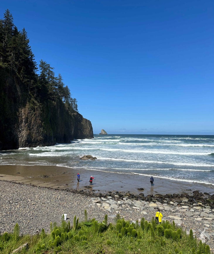
Back on the trail, we approach the headland. Pale sand trails off to smooth rocks, then to a cliffy ledge. There’s a way around it for now, but we’re anxious to scope out the high-tide route just in case. My friend Lauren scrambles her way up a few tight switchbacks and through coastal shrubbery to the other side. My dog, Kona, tugs me forward. Her paws and our boots squish in mud as we pick our way back down to the sand. Now we know there’s a viable return route, even after the tide rolls in. For a moment, I feel relieved.
But on the other side, another obstacle awaits: We can’t find the trail up to the headland. There’s no sign, so I ask a fisherman for directions while he’s rigging a 10-foot rod. He points us to an obscured but well-worn path that climbs to the cape. We pick up our pace.
Our third and most disappointing hurdle comes only at mile two. I’d hoped we could walk the trail all the way to the Cape Meares lighthouse, but the dirt path ends at a parking lot, and the only way to access the landmark is by walking a half mile on the road. A car drives by a little too fast. We decide to turn back.
By the end of our 4-mile hike, we’ll have sampled only a few of the challenges—and delights—that are unique to this trail. None of these hiccups are deal-breakers on our short out-and-back, but the OCT is gaining footing as a thru-hike among local organizers and hiking bloggers. I can only imagine dealing with such obstacles day in and day out. As our unexpected detours add up, any curiosity I’d had about thru-hiking the OCT becomes marred with doubt.
When wildfire smoke and record-breaking snowpack in the Sierra Nevada forced 2017 Pacific Crest Trail thru-hikers to reconsider their plans, many ended up peeling off west to the OCT, a trail with very different hazards than the PCT. Despite the serene beach hiking along towering sea stacks—and miles through mystical, fern-swept forest—it’s still not very popular, with only a handful of thru-hikers traveling the trail every year. (The data isn’t tracked.)
Today, the unfinished trail still features about 40 miles of road-walking. Hikers are either forced to skip the Highway 101 sections, get off the trail to find transportation around them, or play chicken. One particularly dangerous area is the quarter-mile tunnel between Heceta Head and Baker Beach where there’s no sidewalk or guardrail. Daring hikers sprint through it with their backpacks on and pray that traffic slows if it comes.
That same year PCT hikers fled to the OCT, Oregon’s Beach Bill, which famously established the state’s ocean beaches as public domain, celebrated its 50th anniversary. In observance—and after years of persistent urging by the community—legislators passed a bill establishing an Oregon Coast Trail Fund and directing the Oregon Parks and Recreation Department (OPRD) and partners to finally examine gaps in the trail, perilous tunnels included. The new legislation piggybacked a 2011 blueprint and combined short- and long-term strategies to make the trail more appealing as an economy-boosting tourist destination.
“The different agencies and jurisdictions that manage the trail have been chipping away at these segments for a long time, so the things that are left are the hard things,” says Jenna Marmon, the planning and design lead at OPRD.
Six years after the bill passed, state officials in October 2023 released a 93-page plan for upgrading the OCT. Stakeholders include the state’s recreation department, Federal Highway Administration, Siuslaw National Forest, Coquille Indian Tribe, Oregon Coast Visitors Association, and Oregon Department of Transportation. Together, they identified 40 points in the trail that require hikers to travel along roadways or the highway, plus remedies for making the trail safer and friendlier for pedestrians. Solutions range from simply adding wayfinding signs to aspirational strategies—like creating a new water crossing from a boat ramp in Netarts Bay and building completely new trails to avoid Highway 101—that could take decades or longer.
“We all dream of a separated shared use path that parallels Highway 101,” Marmon says. “But the geography, the geology, all of the gamut is just not in our favor.” The plan is the first of many steps in cementing the OCT as a legitimate thru-hike. The hardest phase still lies ahead.

Bonnie Henderson, a hiker from Eugene, Oregon, first solo section-hiked the OCT in 2008 and 2009, completing the northern half one summer and the southern half the next. She has since set foot on the trail hundreds of times, authored three guidebooks including Hiking the Oregon Coast Trail, and helped develop the OCT section on the FarOut app, a popular resource for thru-hikers of the main long trails. “I’m kind of an OCT busybody,” she says. After traveling the full length, Henderson became enamored with helping other Oregonians experience the joys of the trail. The boundless beaches, the windswept bluffs, the teeming forests—she loves all of it.
Henderson says, as far as she knows, she was one of only two people who had backpacked the trail out of the hundreds consulted for the action plan. While the plan’s priority was on attracting day users to the trail and tourism to the coast, Henderson says it has major implications and potential for the long-distance hiking community. “There’s plenty of beach for day walking,” Henderson says. That has never been an issue. The biggest problem with the OCT has always been those 40 gaps—and that’s exactly what the plan is poised to fix.
Projects will happen piecemeal, says Marmon. The ones that will probably unfold faster are those attached to existing plans: The 2022 Oregon Coast Bike Route Plan includes some solutions that will benefit both cyclists and hikers. And city leaders in Yachats are applying for a grant to add sidewalks and a viewing platform to a section of roadway that has an Oregon Coast Trail nexus—a benefit to hikers, but not the only reason for the project. The rest of the solutions will likely have to wait until funding—and agency motivations—catch up.
“It’s the balance between big thinking and pragmatism,” says Marmon. “We want to make sure we have all that aspirational stuff in there, but we also have to recognize it’s gonna be a while before we see it all.”
Henderson remains hopeful. And part of that hope is due to a nearby case study: the Corvallis to the Sea Trail, a 60-mile walkable route that starts at the Willamette River in downtown Corvallis and ends at Ona Beach. Opened in early 2021, the trail was the culmination of nearly 50 years of effort, plus 50,000 volunteer hours and $20,000 in private donations. But ultimately, they made it happen. And if it can happen for Corvallis, maybe it can happen for the OCT, too.
Still, plenty of challenges remain. Compared with other coastal states, Oregon’s entire coast is slow, sleepy, and in some places, sparsely populated, even though 80 state parks dot its length. The largest city on the coast is Coos Bay, with a population of just over 16,000. In southern Oregon where Marmon lives, you can walk days on the trail without seeing a soul.
That’s good for folks who love solitude. But as far as thriving business communities go, there are only so many restaurants, coffee shops, hotels, and ferry services for tourists. I search for a place where Lauren and I can stop for lunch after our hike, but finding the options scant, we decide to just head home to Portland instead. Other amenities are even scarcer.
Had we planned an overnight, our choices of campgrounds would include a county park with hiker-biker sites 20 miles north, two private campgrounds 10 miles east, and a state park campground 10 miles south, according to my FarOut map. (Camping isn’t allowed everywhere on the beach.) State and county parks along the trail don’t always have last-minute availability, and there are long sections of the OCT without any camping (and therefore, restrooms), like the 36-mile stretch between Gold Beach and Brookings, and the 22-mile stretch between Fort Stevens State Park and Ecola State Park—long days of hiking just to get to camp.
The solution is, once again, in the action plan. Aspirations include providing camping every eight to 12 miles along the trail, developing new campsites at state parks, partnering with private campgrounds, and building simple hiker-biker camping spots.
With necessities taken care of, entrepreneurial brainstorming can begin. Folks like Henderson and Marmon wonder: Could the OCT become a coffee camino or hut traverse like in Europe? Could backpackers one day indulge in lobster and beer on a ferry while they cross water sections? The more I think about the possibilities, the more invested I become in this trail’s success.
Business opportunities land in the lap of the Oregon Coast Trail Foundation, a sister entity of the Oregon Coast Visitors Association’s (OCVA). Marcus Hinz, executive director of the OCVA, mentions several possible ideas, and I start to think of more. Beachside hiker hostels? A coastal sauna haven specifically for backpackers? There’s energy for making the OCT even more special than it already is, Hinz says. Now it’s just a matter of building the infrastructure.
“For people who have hiked the trail already and think it’s amazing, you just wait,” Hinz says. “Because you’re going to have to.”
Right now, though, it’s hard to tell how long that wait might be. If hikers want to check real-time trail conditions, the best resource is either the FarOut app or Henderson’s website, Hiking the OCT. There, she details beach camping restrictions and boat ferry schedules. Unlike the PCT, Appalachian Trail, or Continental Divide Trail, the OCT doesn’t have its own hiker association keeping people informed of trail updates. For now, Henderson plays messenger. Currently, she is shepherding a centralized trail information system—called for in the plan—so she can retire.
Up on Cape Meares, we may have missed the lighthouse, but we catch sight of another attraction before turning around. Standing 144 feet tall is Big Spruce, an 800-year-old sitka spruce designated the state champion in 2008 for being the largest of its species in Oregon. There’s even a sign marking its significance. I take a picture and we return the way we came.
Just as I expected, the water is too high to skirt the protruding rock when we exit the trail to the beach an hour before high tide. The fishermen in waders and red, yellow, and blue raincoats are still there, just higher on the rocks. The one I asked for directions is packing up his cooler. We try and fail to avoid the mud on our way over the ledge we’ve already traversed. It’s easy enough to wash off in the ocean, though. Closer to the parking lot, we discover a bench half buried in sand where we eat our snacks in peace. It’s just us, the seagulls, the velella velellas, and a few other beach walkers out there watching the waves. Lauren cold plunges in the ocean, but I hang back with my dog. Next time, I think, giving myself one more reason to return.